
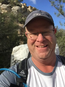
 by Scott Feuer
Mount Diablo State Park is surrounded by over 50 other preserves encompassing a regional open space system nearing 160 square miles that were interlaced with almost 700 miles of public trails. Over the last few years, I had explored much of the Mt. Diablo State Park through strenuous day hikes, summiting all the major peaks and ridgelines, but never realized the potential larger network of open space trails one could explore.
With my Mt. Diablo map spread out on the dining table, I contemplated my next weekend-warrior day hike.
Day 1 Day 2 Day 3
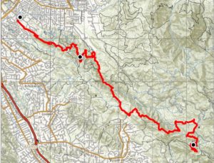
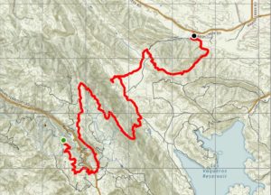
Could one hike from one side of the map to the other? With a yellow highlighter, I began tracing trails south from Lime Ridge Open Space in Walnut Creek across the western slope of Mt. Diablo to Round Valley Regional Preserve on Marsh Creek Road. Tallying up the mileage and studying the topography I estimated the hike to be about 45 miles with roughly 9,800 feet of elevation gain.
“Three days, 15 miles a day, that’s feasible, although, I would have to camp two nights and carry all my food and gear. A baby thru-hike!” I rationalized. This would provide some good training experience to section hike the Mexico to Canada’s Pacific Crest Trail (PCT). Over the next few, weeks I prepared logistics and collected the necessary supplies, excited to temporarily escape the tense energy of work deadlines, to-do lists, and other daily routines.
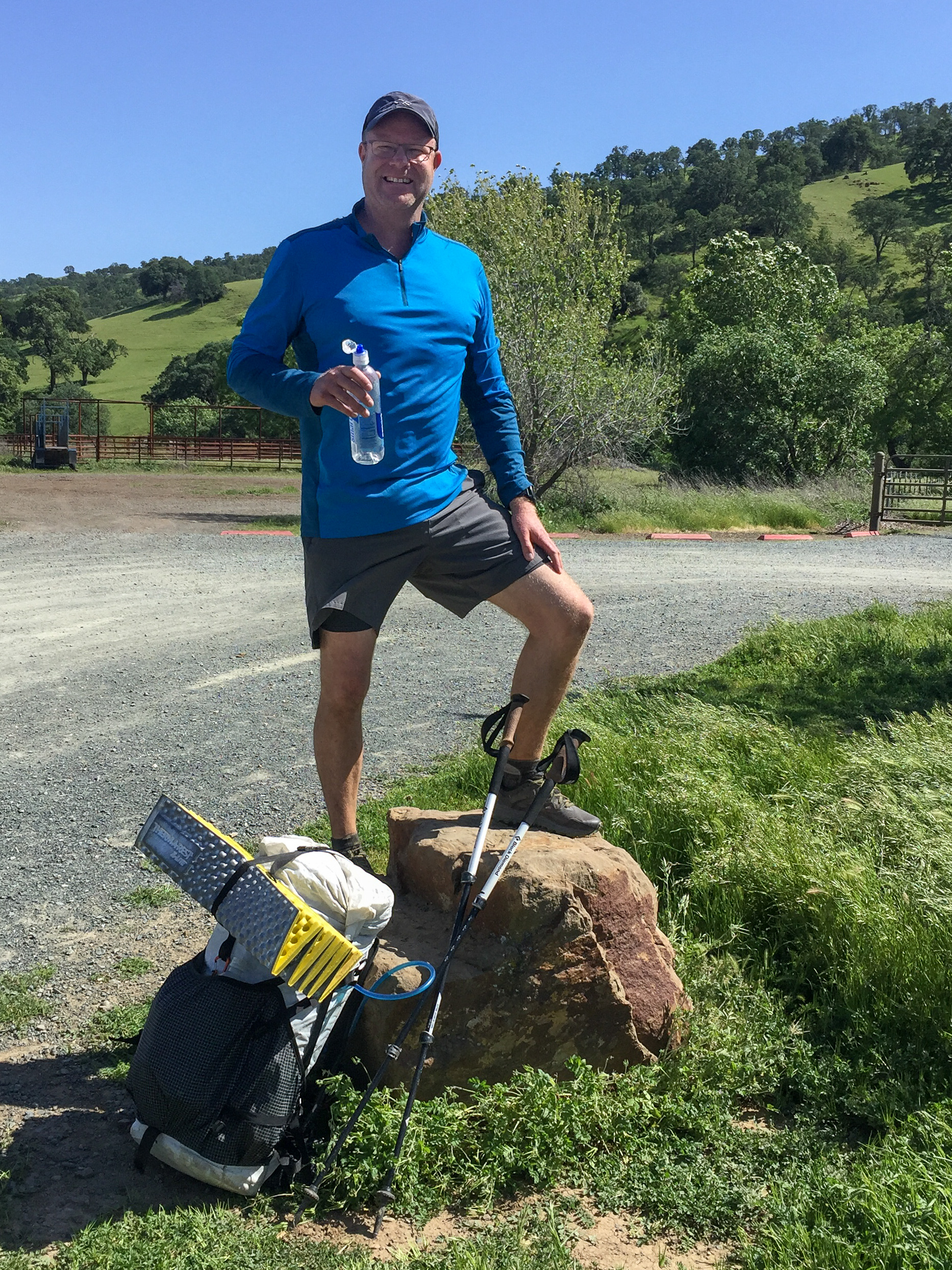
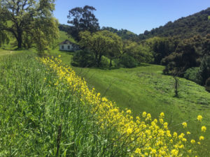
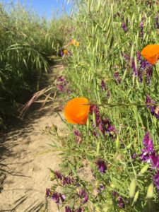 I was dropped off at the trailhead parking lot behind John Muir Hospital in Walnut Creek with my backpack and trekking poles ready to begin my solo thru-hike. The spring rains had nourished a thick blanket of tall vivid green grasses which practically concealed the beginning of the trail. After a few minutes of searching, I found the 18- inch wide ribbon of dirt that would become my home under my feet for the next three days. Within only a couple of minutes of hiking, the morning dew saturated my lightweight trail running shoes. Every footstep squished with a soggy unnerving sound of slush…and only 15 miles to go.
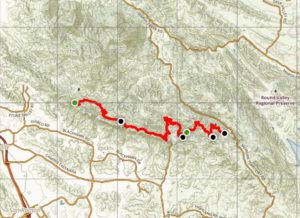
As the sunshine intensified, I navigated through waist-high high grasses and realized, “Rattlesnakes!” Slowing my pace, for the next couple of miles, I extended my trekking poles in front of me and relentlessly waved them back-and-forth to announce my presence, ears attune to the sound of rattling. I successfully made my way into Borges Ranch to top off my water supply before heading into Pine Canyon.
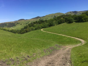
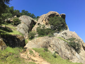 Pine Canyon’s steep sandstone formations rising out of valley’s riparian oak woodlands provided a scenic natural landscape filled with interesting geologic features, abundant wildflowers, and nesting peregrine falcons which were successfully reintroduced back into the area during the 1990s. I veered south on Little Yosemite Trail up to the open oak savannah grasslands finally reaching Rock City at Fossil Ridge.
 Live Oak campground is typically booked solid during the summer, but this early spring adventure found only a handful of campers. I unshouldered my 24 lb. backpack, set up my tent and enjoyed a warm dehydrated cowboy chili stew dinner. Then it was time for a little stargazing before crashing to sleep.
Day Two: I awoke at sunrise, stretched my stiff legs, and warmed a cup of coffee with my ultralight camp stove. Having stuffed my gear into my backpack, I was off again meandering up through the sandstone rocks and wind caves of Rock City.
Making way to Oyster Point Trail through beautiful chaparral and sweeping surrounding views, I pass a lone hiker who became the only person I saw for the next 24 hours on this single-track trail. However, I observed coastal black-tailed deer, cottontail rabbits, butterflies, and a couple of ring-neck snakes (which are slightly venomous, but completely harmless), not to mention the many species of song birds in the tree canopies above.
 After a short stop at Jackass Canyon to filter water from Tassajara Creek, I climbed up to Amphitheater Trail through the centuries-old oak trees to break for lunch. I found multiple large smooth rock outcroppings which were sprinkled with mortar grinding holes used by Native American Indians. After lying down and watching cloud formations overhead, I drifted off for a quick nap. Then packed up and continued east.
The afternoon warmed, and I was continuously gaining elevation. My water supply from the last natural spring was almost gone and I had at least six more miles to go until arriving at the next camp. Atop the ridgeline, the possibility of finding a seasonal water source to drink from was nearly impossible. According to my map, I could divert a mile downhill to a potential seasonal creek in hopes of quenching my thirst. The decision was clear. I had to find water even though I knew the hike out of the valley back to the ridgeline would be formidable.
 The heat persisted with no afternoon winds. As I reached the valley bottom near Sulphur Springs, I made my way through a substantial thicket of Poison Oak maneuvering cautiously around each branch down to the creek edge. To my disgust, the creek was extremely shallow and muddied with hundreds of wild boar footprints scattered in the evaporating puddles of water. This would be a great commercial for my water purifier filter! I had no choice but to find the cleanest depression of remaining water and refill my water bottles. Relieved to “camel up” and rehydrate myself, I then addressed the challenge of hiking up the steep Jeremiah Trail back to the ridgeline.
The hot, treeless, south facing trail certainly dampened my morale; that and sweaty clothes, two days of hiking with no shower, inner thighs chafing with every step, and drinking filtered boar-foot infested water. Note to self, “next time, pack anti-chafing cream, ointment, powder whatever works”.
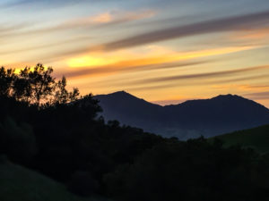 I reached the ridgeline and with a “hiker’s hobble”, I painfully made my way to Morgan Backpack Camp. First order of business was to wash up with baby wipes, change out of my sweaty hiking clothes, and conduct some make-shift laundry time with a large zip-lock bag and biodegradable soap to prep my clothes for the next day of hiking. I ended up having a quiet evening enjoying a beef jerky/top ramen noodle dinner and a few sips of whiskey. I watched the stars track the night sky from the comfort of my down sleeping quilt mesh fabric tent.
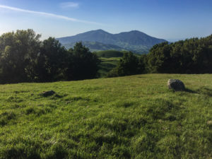
Day Three. I awoke and devoured a dehydrated egg omelet and hot oatmeal breakfast then hit the trail early. By around 9:30 am, I wandered into the staging parking lot at Morgan Territory Regional Preserve.
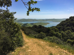 The last 11 miles lead me down the Coyote Trail ravine, through old-growth stands of majestic coral-red trunked Manzanita shrubs, and up and over the Miwok Trail with exceptional views of the aquamarine colored Los Vaqueros Reservoir. Once down in the valley, I briefly detoured through the expansive cow pasture to see the Round Valley backpack campsite for future reference and enjoyed a delicious tortilla, cheese and salami makeshift burrito for lunch. Packing up for the last time, I headed off towards the incline of Hardy Canyon Trail hiking east around the last peak and back down to the Round Valley equestrian staging area parking lot for my arranged extraction point and short reverse commute drive home.
I accomplished my goal. A solo thru-hike across the Mt. Diablo range, but more importantly, I discovered one could do so in almost complete solitude while immersed within a beautiful natural landscape setting only miles from home. This trip was a definite staycation adventure to remember. Kudos to Save Mount Diablo and all the other organizations and volunteers who help protect and manage
GEAR LIST Total weight (referred to as Base Weight) 18.21 lbs. Full backpack weight with water, fuel & Food 24.0 lbs. (varies through the trip)
Base Gear
- Backpack
- GPS Device
- Smart Phone
- Head Lamp
- Battery Power Bank
- Pocket Knife
- Rope
- Compass/Mirror
- Journal & Pen
- Cat Hole Shovel
- Small First Aid Kit
- Duc Tape Strips
- Stuff Sacks
- Sitting Pad
- Trekking Poles
- Map
Water Purification
- Water Filter
- Backup Water Treatment Tablets
- Water Bladder
- Plastic Water Bottles
Sleeping System
- One person Tent & Footprint
- Sleeping Quilt & Bag Liner
- Inflatable Sleeping Pad
- Inflatable Pillow
Clothes
- Hiking Clothes – long sleeve shirt, running shorts w/liner, hat socks, and trail running shoes
- Sleeping Clothes – long underwear, gloves, beanie
- Additional Clothing – Puffy jacket, rain jacket, rain kilt, pants, belt, sunglasses, bandana
Cooking Gear
- Mini camp stove & Lighter
- Fuel canister
- Small Pot and Mug
- Spatula, Spoon, Knife
- Mini Coffee Filter
- Small Sponge
Personal Hygiene
- Sunscreen/Lip Balm
- Insect Repellent
- Biodegradable Liquid Soap
- Antibacterial Wipes
- Body Wipes
- Mini toothbrush & Toothpaste
- Piece of Dental Floss
- Toilet Paper
MEAL PLAN
Day One:
- Snack – Trail Mix/Nuts
- Lunch – P&J sandwich, Cheese Crackers, Cookies
- Snack – Power/Sports Bar
- Dinner – Dehydrated Cowboy Chili Stew, Cookies, Flavored Water
Day Two:
- Breakfast – Dry Milk, Muesli Cereal, Carnation Instant Breakfast Mix, Coffee
- Snack – Bagel w/ Nut Butter Spread
- Lunch – Tortillas, Tuna, Babybels Cheese, Mayo & Mustard Packs, Flavored Water
- Snack – Candy Bar, Trail Mix
- Dinner – Top Ramen Noodles w/ Beef Jerky, Cookies, Flavored Water
Day Three:
- Breakfast – Dehydrated Egg Scramble and Instant Oatmeal w/ Dried Fruit, Coffee
- Snack – Beef Jerky, Trail Mix/Nuts
- Lunch – Tortillas, Salmi, Cheese Sticks, Mayo & Mustard Packs, Flavored Water
- Snack – Power/Sports Bar
- Dinner – At Home
Scott Feuer passionately enjoys the outdoors via hiking, backpacking, kayaking, fishing, and photography (often going solo). He also enjoys photography – see more pictures on his Website at https://sefpics.myportfolio.com/